Ringwall adventure
When visiting the Celtic Ringwall Otzenhausen you will find information boards along the way. There you can learn more about your current position and the historical background.
To prepare for your trip or just to learn more about the Celts in the region you can browse the information boards here.

Overview
The Celtic "Hunnenring" circular stone wall in Otzenhausen
The folkloric name "Hunnenring" ("Circle of the Huns") designates one of the biggest fortifications of the Celtic world. The old designation "Hunnenring" suggests the possible existence of the Huns in this region. This interpretation has, however, been proved nonsensical.
The fortifications are situated on the edge of the Hunsrück Nature Park, on the "Dollberg" near Otzenhausen, 695m above sea level.
Explanations regarding its function vary from it being purely a refuge keep, via an oppidum (a townlike settlement), to a seat of power and rulership or aristocracy. Topographically, the "Hunnenring" lies at the southern extremity of the territory of the Celtic Treveri tribe.
In all probability constructed as early as the 5th/4th century B.C. (at the end of the Hallstatt culture) as a defence against the Germanic peoples, the fort experienced its heyday in the 2nd and 1st century B.C. (age of the Latène culture). In the 1st century B.C. it was abandoned for reasons as yet unknown.
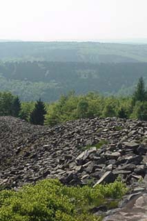
The site is triangular in shape. It is divided into a main fort and an outer fort. From east to west it extends 460m, from north to south 647m. This results in an overall area of 18.5 hectares, making the "Hunnenring" one of the largest Celtic fortifications ever built.
The stone walls are around 2500m long and are built from approximately 240,000 cubic metres of stones, which corresponds to the load of around 9000 railway trucks. The dimensions of the site are still very impressive today.
10 signposted vantage points lead you in a circular route to the most important points of the fort. Distance approximately 4 kilometres, some steep inclines. Walking shoes or boots are recommended.

Geology
Geologically, the Hunsrück Natural Park consists of strata of Devonian rock (approximately 405-350 million years ago). At that time, vast areas of what is now Central Europe lay in a sea basin, the so-called geosycline sea, which was an extension to the north of the present-day Mediterranean. In the middle of this Devonian basin lay the so-called Middle European Island. Sediment deposited on the island's north coasts. In the subsequent geological periods, these loose sands underwent changes. Through an increase in pressure and temperature resulting from the ever thicker overlying formations of younger strata and tectonic events such as folding (in the Lower Carboniferous approximately 350-325 million years) and shifts within the rock deposits, the Taunus quartzite emerged, which is impressively manifested here on the "Mannfelsen".
In the Tertiary Period (approximately 60 million years ago) new elevations gave rise to the principal characteristics of our present-day landscape relief of mountains and valleys. During the geological epoch of the Quaternary (1.5 million years until today), so-called sub-glacial lakes or moraines developed during the Würm Ice Age on the elevated plains of the Hunsrück hills over 330m above sea level.
Through erosion or weathering processes such as abrasion, rubbing due to frost or temperature weathering, sub-glacial terrain broke loose from the rock face and deposited on the lower slopes (after 200m to the left, you can see remains of such a moraine).
These stone deposits at the same time provided one of the main prerequisites for the building of such a vast fortification as the "Hunnenring", namely the construction material. It lay directly on the site, and only needed to be collected and as a result not specially mined in quarries.

The Gateway
In the course of excavations in the years 1936-1939, the gateway with its adjoining walls was discovered.

The gateway was double-winged and 6m wide. Separated by the central post into two gates of 2.5m each, it comprised a separate entrance and exit. The wooden posts sunk into the holes of the gatepost were wedged with stones. A layer of gravel covered the ground and allowed passage even in wet weather.

The gateway was crowned by a wooden battlement. The slightly inset battlemented parapet and projecting wall constitute a construction resembling an outer bailey. With this, it was possible to fight against attackers from three sides at once.
Looking to the right, you can see the outer wall. It encircles the entire southern section of the site. Its significance is not known. Possibly it served as a barrier for livestock or it signalled an earlier and more extensive construction period.

The Spring
Due to the impermeable Taunus quartzite, the water from the spring came to the surface relatively high up in the hills.
As recently as the 19th century it could still boast running water the whole year through. It flows into reservoirs. Under the wall, an outlet channels the surplus water to the outside.

The spring has a protective significance. In times of siege, there was plenty of water for men and the animals alike.

Apart from water supplies, it was also necessary to store food within the fortress. This would have consisted of various grains that were cultivated and harvested in the surrounding area. Typical varieties were husk barley, two-grained wheat, one-grained wheat, spelt, oats and common wheat.
Furthermore, pulses such as lentils, peas and common vetch were cultivated. Added to this is livestock breeding. Swine (approximately 53%) and cattle (approximately 34%) were bred. Dogs as well as water fowl featured on the extended menu. By contrast, hunting played only a subordinate role.

Early monument preservation and history
The earliest known mention of the enclosure wall was recorded in the Grimburger Salbuch (geological register) of 1589; a first graphic representation of the enclosure walls from the feuilleton of the Gazette de Metz from 1836.
In 1836, Count Villers von Burgesch drew up a petition addressed to the then Prussian king Friedrich Wilhelm III. It contained the plea forbidding the inhabitants of Otzenhausen and the surrounding districts to carry off stones for use as building material. In reply, the then Prussian Crown Prince Friedrich Wilhelm IV paid a personal visit to the "Hunnenring" in 1837. This outcome of this visit protected the enclosure wall from destruction.

The depicted plan from the year 1883 testifies to the visit of the Crown Prince. It shows the inclusion of a so-called "royal lodge" situated to the north-east where the galleries over the enclosure wall intersect. To mark the occasion of the royal visit, the Crown Prince was received here and in his honour a tree - also recognisable on the plan - planted. On the occasion of this visit, the stairway over the north wall - which is still passable today - was built.

The monuments of our history deserve special protection. That is why this entire site is classified as a historical monument.
Every stone that is removed from here destroys a small part of our common past! For that reason we ask you not to take away any objects or stones and to report any acts of destruction or pillage you may witness!

Former excavation area
The first unsystematic excavations on the site of the "Hunnenring" took place in 1883 in the vicinity of the spring and the main wall.

After that, more than 50 years passed before the first systematic investigations were carried out between 1936-39. Here, apart from the uncovering of the gatehouse and a - failed - excavation of the north wall, the excavators studied an extensive 3000 m² area in the region to the south of the present refuge.

Numerous holes from construction posts bear witness to a multi-stage settlement here in the 2nd and 1st centuries B.C.. The half-timbered houses served either as storehouses or living accommodation.

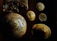
Finds of shards of ceramic objects, spinning whorls, iron slag, iron tools such as knives, axes, hammers, drills, a number of coins etc. provide an insight into the everyday life and craftsmanship skills of the inhabitants.
Excavated sections suggest that a settlement in other parts of the interior area can also be assumed.
The entire excavation area covered only 3% of the total interior area. Thus, numerous important questions regarding the significance and function of the site, its date of origin, its settlement structure etc. remain unanswered. To answer these questions is the task of the current scientific excavations.


Roman Temple
During the original excavations, the foundation walls of a small temple dating from the 2nd and 3rd century A.D. were discovered. The tiny temple measured 2.70m x 2.15m. The walls were built from quartzite rubble stone, which on the outside had been faced with imported brick-shaped sandstone. The wooden roofing timbers supported a covering of slate and clay roofing tile.

Nearby deposits of spear and lance heads, arrowheads, a wild boar relief and the bronze figure of a female god (finding place uncertain!) were found.

These intentionally deposited objects are obviously consecrated religious offerings in honour of the temple god. This will have been a god (Mars) or hunting goddess (Diana).

To what extent this temple is linked to the temple site of Schwarzenbach, only 1.5 km away in the village district of "Spätzrech", remains unclear. From the 1st to the 3rd century A.D. there existed there a larger Roman temple site dedicated to the god Mars Cnabetius.

The lack of other finds within the site leads to the conclusion that during Roman times there was no settlement within the confines of the one-time Celtic fort.

The Main Wall (North Wall)
Constructed in order to block off the populated mountain crest from the remaining flat mountain ridge, the main wall for defence reasons had to be considerably stronger than the side walls. The north wall was stronger than any other fortification wall of the day. At over 10 m high and 40m thick, the wall remains we can still see today give an imposing impression of what it must have been like. At the time of its greatest extension, the wall was around 20m high and equally as thick. This corresponds to around the height of a five-storey building.

The typical construction method for Celtic fortification walls was described by Caesar as "murus gallicus" (Latin = Gallic wall). Excavations confirm that the enclosure wall of Otzenhausen was also constructed according to this principle. It is based on a wooden and nailed-together framework of logs, with the inner cavities being filled with earth and stones. The outer facade of the wall was covered with a dry stonework. The present-day talus cone is the result of several construction phases, about whose age and appearance little is known. It can be presumed that the defence walls and hence the entire site date back to the early Latène period (5th-4th century B.C.).
The "Hunnenring" was probably most recently abandoned without a struggle in the middle of the 1st century B.C. during or just before the Roman occupation.
The warring methods of the Celts: attacking enemies were kept at bay with spears, arrows and bows as well as catapults. Lance, dagger and sword were used for hand-to-hand combat. Shields offered additional protection.
Celtic Graves
The barrow excavated in 1938 and still visible today has a diameter of 22m. The height today is 0.8m, whereas the original height was 4-5 times greater.

The main central grave of the barrow was already plundered by grave-robbers in ancient times. A few ceramic finds nevertheless allow the barrow to be dated back to the more recent Hunsrück-Eifel culture (6th-5th century B.C.). The remains of a second burial were also discovered. This bore two bronze bracelets as burial treasure and is dated somewhat more recently than the central burial.

Burying the body under a barrow or cairn was the typical burial rite of the Celtic peoples until the 5th century B.C.. The higher the person's rank, the greater the communal expenditure when it came to constructing the burial pile and/or the richer the burial treasure.
In the 5th/4th century B.C. the burial tradition shifted to flat graves. From then on, the coffin with the body was laid in a hollow in the ground. The grave mound above ground was no longer the fashion.

The richly endowed princely graves in the neighbouring village of Schwarzenbach reflect the aristocracy. Its prosperity could be traced back to the iron ore deposits in this region. Were the princes of Schwarzenbach also the builders of the "Hunnenring"? One thing is certain, a contemporaneity between the oldest settlement findings from the enclosure wall and the burial treasure found in the Schwarzenbach princely graves can be proved beyond doubt.

Ironworking
What is the significance of this high forest region that led to such vast fortifications as the ring-like wall of Otzenhausen or the rich princely graves of Schwarzenbach being constructed?
The reasons for this wealth and prosperity are to be found in the local deposits of iron ore. The "Lebach strata" mined above ground produced large quantities of iron clay. Even today, numerous basins like, for example, the "Kloppbruchweiher" lake next to the exit to the forest car park bear witness to this mining activity.

The so-called "Lebach eggs" mined here - kidney-shaped lumps of rock - have fossil remains at their core.
The lumps of ore were mined, gathered and exposed in the open air to frost and the elements, causing the dead rock to separate from the ore-bearing rock. Subsequently, the ore-bearing mineral was melted down and processed at the forge into tools, machines and weapons.

Initial metallurgical analyses of slag and manufactured products from the early excavations at the "Hunnenring" provided evidence of a forging method that as a result of using high temperatures (up to 1000 degrees Celsius) and repeated cooling in the air gave the iron steel-like properties.

If these findings should be confirmed in serial analyses, it would be evidence that the particularity of the local production lies in the production of steel. In the second half of 1st millennium B.C. this would certainly have been a precious material that would justify the high settlement intensity as well as the dimensions of the fort on the Dollberg and the magnificent endowment of the graves.
